Understanding Rivers and Drainage Basins #
A river is a natural flowing watercourse that moves from higher land to lower land. A drainage basin (also called a watershed or catchment) is the area of land that collects water and drains it into a particular river.
Think of a drainage basin like a giant funnel – all the rain that falls within its boundaries will eventually flow into the main river and then to the sea.
Key Features of Drainage Basins #
Essential Drainage Basin Features #
| Feature | Definition | Key Points |
|---|---|---|
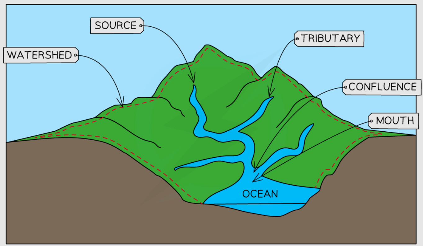
| Source | The starting point of a river | Usually in mountains or hills; may be a spring, glacier, or lake |
| Mouth | Where the river ends | Usually flows into the sea, lake, or another river |
| Tributary | A smaller river that flows into a larger river | Increases the main river’s discharge and size |
| Confluence | The point where two rivers meet | Where a tributary joins the main river |
| Watershed | The boundary of a drainage basin | Usually follows ridges and high ground; separates one drainage basin from another |
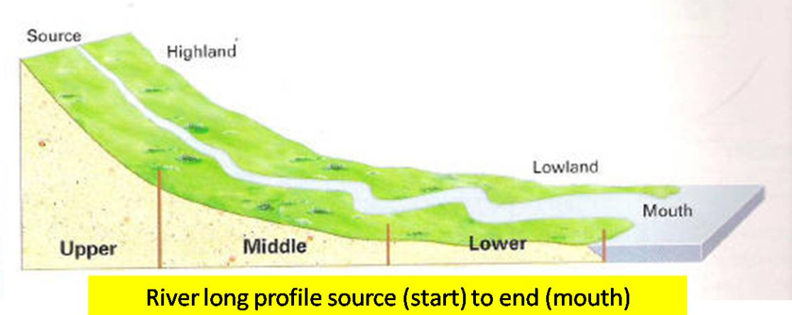
The Long Profile of a River #
The long profile is a diagram that shows how a river changes from its starting poing (source) to its ending point (mouth). It shows the river’s gradient (slope) and height of the river above sea level along the full length of the river.
Long Profile Characteristics #
The long profile typically shows:
- A Steep slope (or gradient) in the upper section of the river (near the source)
- A more gletle slope in the middle section of the river
- Almost flat ground in the lower section of the river (near the mouth)
This creates a shape called a concave curve – Its steep at the start, then gradually flattening out towards the end.
River Channel Characteristics #
A channel is simply he PATH that the river’s water follows. A river channel changes from the source point (start) to mouth point (end). Below are some characteristic of each section of the rivers path
Upper Section (Upper Course) #
- Width: Very narrow , usually 5-6 meters wide
- Depth: Shallow but with deep valleys
- Gradient: A very steep slope
- Channel Shape: V-shaped like a valley
- Water Flow: Fast, high pressure (turbulents), lots of friction
Middle Section (Middle Course) #
- Width: Wider channel
- Depth: Deeper channel
- Gradient: A more gentle slope
- Channel shape: Wider valleys, some meandering (meandering means turning left or right)
- Water Flow: Smoother, less pressure (turbulents)
Lower Section (Lower Course) #
- Width: Very wide channel
- Depth: Deep channel
- Gradient: Almost flat ground
- Channel shape: Wide valleys, large meanderings
- Water Flow: Smooth water flow
Key River Measurements #
There are various things that we can actually measure about a river. Below is a list
Speed of the water Flow (River’s Velocity) #
Velocity is the speed at which water flows through the river channel. It is measured in meters per second (m/s).
Discharge #
Discharge is the amount of water (its volume) that is passing through the river’s channel at any given point. It is measured in cubic meters per second (m³/s), also called “cumecs”.
Discharge Formula #
Discharge = Velocity × Cross-sectional Area
$$\text{Discharge (m³/s)} = \text{Velocity (m/s)} \times \text{Cross-sectional Area (m²)}$$
Cross-sectional Area = Average Depth × Width
$$\text{Cross-sectional Area (m²)} = \text{Average Depth (m)} \times \text{Width (m)}$$
Discharge increases downstream because:
- More tributaries join the main river, adding more water to it
- The channel becomes wider and deeper, so it holds even more water
- More surface water and groundwater entering the river
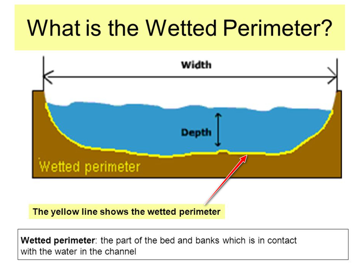
Wetted Perimeter #
Wetted perimeter is the length of the river bed and banks that are in contact with water. It affects the efficiency of the river channel.
Why Wetted Perimeter Matters #
The wetted perimeter creates friction that slows down the river. A longer wetted perimeter means more friction, which reduces the speed (or velocoty) of the water flowing in the river.
How Rivers Change From Source to Mouth #
Understanding how rivers change helps explain many geographical processes and landform development.
| Characteristic | Upper Course | Middle Course | Lower Course |
|---|---|---|---|
| Altitude | High (mountains/hills) | Medium (rolling hills) | Low (near sea level) |
| Gradient | Steep | Moderate | Gentle/flat |
| Channel Width | Narrow | Wider | Very wide |
| Channel Depth | Shallow | Deeper | Deep |
| Velocity | Low (high friction) | Medium | High (low friction) |
| Discharge | Low | Medium | High |
| Main Process | Vertical erosion | Lateral erosion | Deposition |
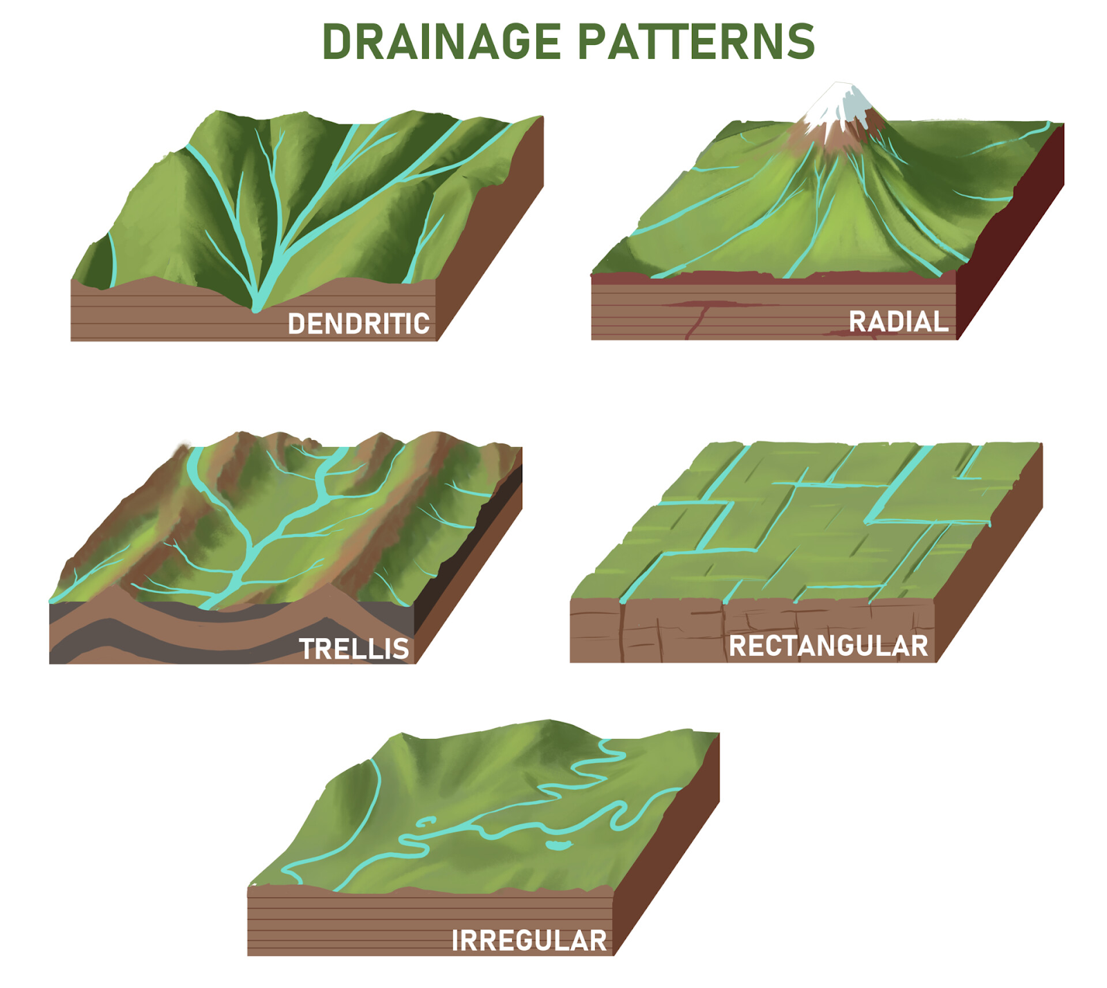
Drainage Basin Patterns #
The shape of drainage basins depends on the landscape and rock types. Understanding these patterns helps explain how water moves through the landscape.
Common Drainage Patterns #
- Dendritic: Tree-like pattern – most common, forms on uniform rock types
- Trellis: Rectangular pattern – forms when rivers follow geological structures
- Radial: Rivers flow outward from a central high point like a dome or volcano
Why These Characteristics Matter #
Understanding river and drainage basin characteristics helps explain:
- Landform development: Why waterfalls form in upper courses but deltas form at mouths
- Flood risk: How discharge changes affect flooding potential
- Erosion patterns: Why rivers erode vertically upstream but laterally downstream
- Human activities: Where settlements, transport, and agriculture develop
- Water management: How to predict and control river behavior


